By
Annette Price
Date
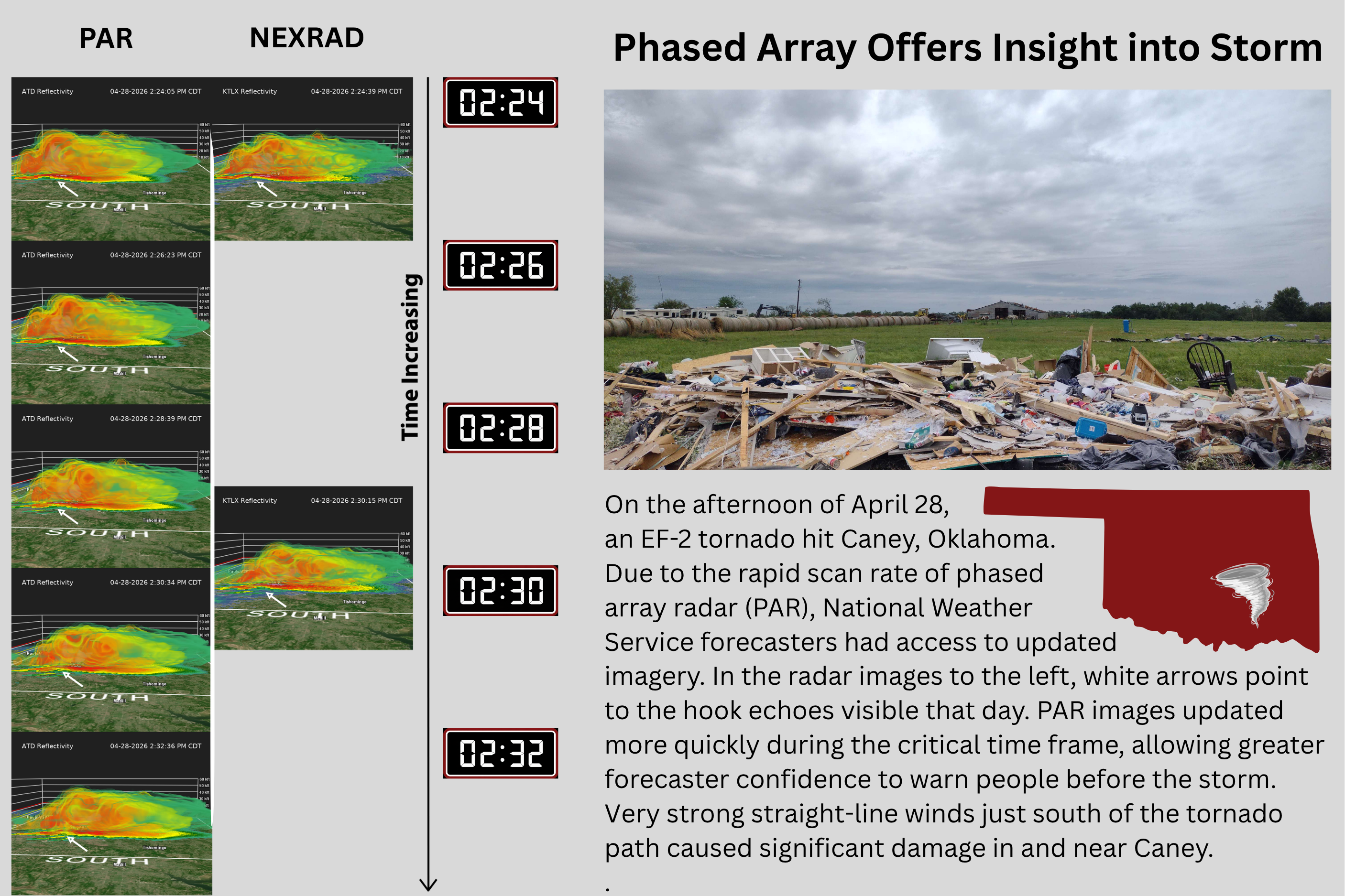
NORMAN, OK (May 18, 2026) — Meteorologists and engineers achieved a research milestone when phased array radar was used in operations for the first time ever to help National Weather Service forecasters warn of an EF-2 tornado that hit Caney, OK, on April 28.
The phased array radar (PAR) research and development effort is a collaboration between NOAA’s National Severe Storms Laboratory (NSSL) and the Cooperative Institute of Severe and High-Impact Weather Research and Operations (CIWRO) at the University of Oklahoma. The shared goal is to develop the next generation of weather radar, fundamentally changing how severe weather is tracked.
The PAR data was collected using the Advanced Technology Demonstrator (ATD), a single-face, polarimetric PAR in Norman used to investigate the capabilities that this technology could potentially bring to a future nationwide radar network. Today, NOAA’s National Weather Service operates the WSR-88D (NEXRAD) network — about 160 dish-based radars across the United States — the backbone of weather data collection for decades. The ATD is helping researchers and forecasters envision the next generation of that network, demonstrating how PAR could deliver faster updates, greater flexibility and enhanced performance in high-impact weather situations.
On the afternoon of April 28, National Weather Service (NWS) forecasters in Norman turned to PAR data to make warning decisions after technical issues arose with the area’s operational WSR-88D radar, KTLX, earlier that day, said CIWRO research scientist Kristofer Tuftedal.
“They have been using it as a supplement to the data that KTLX provides this spring, but this is the first time that they specifically cited using PAR data for warning decisions. The ATD data was a big part of their decision to issue a tornado warning earlier than they would have with the WSR-88D data they typically use,” Tuftedal said.
Revolutionizing how we see storms
The PAR data provides forecasters with a more seamless visual of the storm’s progress. Unlike conventional radars that mechanically spin, the ATD’s flat panel steers its beam electronically — delivering low-level scans every minute or less instead of every 2-3 minutes, and full volume scans in less than 2 minutes instead of 5-7 minutes.
“Forecasters don’t have to try to picture in their heads what is going on between this scan and that scan, and they don’t have to wait several minutes to confirm if what they are seeing is a real threat or not. They can just watch it evolve,” Tuftedal said.
The ATD is the first S-Band polarimetric PAR designed for weather observations. Development began in 2016, and it became operational in 2021. To date, the ATD has captured more than 600 hours of weather data, creating a rich and growing dataset that is driving innovation and accelerating the maturation of PAR technology. Capabilities of the ATD are also tested in the NOAA Hazardous Weather Testbed (HWT), a collaborative space where researchers and NWS forecasters from around the country evaluate the benefits of PAR data in the warning decision process. The NOAA equipment is operated and maintained in part by CIWRO.
Driven by collaboration
The radar is run by a small group of CIWRO and NOAA engineers and scientists — the Advanced Radar Techniques (ART), Radar Engineering Development (RED) and Precipitation and Advanced Radar Studies (PARS) teams — who handle everything from software development and hardware maintenance to meteorological evaluation and real-time support.
The ART team runs vast amounts of strenuous testing on the ATD and pushes two major software updates every year to enable new scanning capabilities while ensuring that the data is trustworthy. Stephen Gregg, an ART software developer with CIWRO, said the ATD has already been operating at a very high standard.
“The ATD being ready for its big moment wasn't an accident, but is instead a testament to software and longevity testing. Because of the exceptional work that the ART and RED teams have done, nothing extra had to be done that day for operations or forecasters to receive this advanced data. Providing clear, timely data is what we take pride in.”
OU graduate student Willow Phipps was operating the ATD radar that day. Phipps is a graduate research assistant at CIWRO.
Mark Fox, meteorologist in charge at the NWS Weather Forecast Office in Norman, said the PAR data was essential on April 28.
“Watching PAR data in real time helped us make several tornado warning decisions, as well as several calls to not issue. The data coming in much more frequently than the typical data is a golden ticket that increases forecaster confidence,” Fox said.
Seeing storms in unprecedented detail
The addition of high-quality Doppler velocity and polarimetric data helped to make ongoing storm-scale processes very apparent as forecasters watched the atmospheric conditions around Caney that day.
“On April 28, the rotation was so clear in the reflectivity data alone that you didn’t even have to look at the velocity data to see that there was a strong rotation signal,” Tuftedal said. “Data from the dish radar is like watching stop-motion animation, like claymation. The PAR data, in comparison, is like looking at a 60 frame-per-second video. You can really get the sense that the atmosphere behaves like a fluid when looking at the PAR data.”
Polarimetric data is collected by transmitting both horizontal and vertical polarized microwaves, enabling forecasters to distinguish between rain, hail, snow and non-weather objects like debris, Tuftedal said.
“Due to the way that PAR beams are electronically steered, polarimetric data has been difficult to attain with past PAR systems. The engineers working with the ATD have worked tirelessly to ensure that the polarimetric data are high quality and well calibrated; one of many efforts that have made the ATD the high-caliber research system it currently is,” Tuftedal said.
As the current generation of radar ages out, phased array radar may be able to make speed improvements in forecasting nationwide.
From research to real-world impact
Teams at CIWRO and NOAA have been advancing PAR technology for more than two decades, pushing the boundaries of how we observe and understand the atmosphere.
“Transforming technology originally developed for military applications into a powerful tool for weather observation has been an incredibly rewarding journey,” said Sebastian Torres, Associate Director at CIWRO and leader of the ART Team.
“We have clearly demonstrated that PAR technology offers game-changing advantages over traditional dish radars, especially in high-impact situations when every second matters for saving lives and protecting property.” he said. “I’m truly excited about what lies ahead. PAR is unlocking entirely new ways to scan the atmosphere faster, more precisely and more intelligently than ever before.”
For Patrick Servello, RED Team Lead with CIWRO, the work is hard but the payoff is unique.
“How many other jobs can say that even though their project isn’t in production per se, it is still affecting lives?” Servello said. “So it’s super exciting.”
Gregg says PAR’s contribution to the correct forecast in Caney proves that the technology is a viable, high-performance solution, capable of providing meaningful data and continuity for the nation’s weather surveillance efforts,
“Our collaboration with the NWS during last month's tornado event marks a major milestone in the transition from fundamental research to operational reality,” Gregg said. “By leveraging two decades of PAR development, we successfully provided critical data when it was needed most.”
Meteorologists and engineers achieved a research milestone when phased array radar was used in operations for the first time ever to help National Weather Service forecasters warn of an EF-2 tornado.
The 3D Mesonet project aims to make advancements in gathering spatiotemporal atmospheric data in the United States, allowing scientists to better predict short-term, high-impact weather, like thunderstorms, severe winds and winter precipitation.
Greg McFarquhar, director of the Cooperative Institute for Severe and High-Impact Weather Research (CIWRO) and Operations and a researcher at the University of Oklahoma, has been awarded funding from the U.S. Department of Defense (DoD) to compile and analyze cloud property measurements from around the world.