By
Annette Price
Date
NORMAN, OK — The latest version of an innovative and reliable suite of weather forecasting and monitoring software became operational at the National Weather Service this week, marking 11 years of continual improvements for the state-of-the-art system.
The Multi-Radar Multi-Sensor (MRMS) system, which integrates data from radar, satellite, rain gauges, lightning networks and weather forecast models, has been a key tool that NWS forecasters have relied on in extreme weather events since 2014. MRMS was developed and has been maintained by researchers at NOAA’s Cooperative Institute at the University of Oklahoma in collaboration with the NOAA National Severe Storms Laboratory (NSSL). It is constantly being updated with new scientific advancements. Before these are transitioned into service they are extensively tested to ensure only the highest-quality data reaches forecasters.. In fact, MRMS now has 135 different products and tools in operation at the NWS.
The new version, MRMS v12.3, features updates relating to radar processes as well as advancements to severe weather and precipitation product algorithms, said Steven Martinaitis, senior researcher at OU’s Cooperative Institute for Severe and High-Impact Weather Research and Operations (CIWRO). Even as MRMS v12.3 is launched, CIWRO scientists are already reviewing the performance of various products within MRMS to investigate ways to further enhance the technology for the next update.
A major strategy being explored by CIWRO researchers is testing new cutting-edge science for better prediction of flash flooding events like those across the United States this summer.
“The MRMS system and its companion Flooded Locations and Simulated Hydrographs, or FLASH, system have provided key information on precipitation estimates, rainfall analyses, and flash flood predictability. The technology has been there when our partners at the National Weather Service have needed that critical information the most,” Martinaitis said.
“Highly trained forecasters combining the MRMS and FLASH data with their expert experience, and integrating this data into their warning decision-making process helps build that confidence on when and where to issue a warning. However, we continuously evaluate how each product and system performed and what areas can still be improved upon,” he said.
Over the last few years, researchers have experimented with combining the MRMS and FLASH system with another emerging weather prediction technology: the Warn on Forecast System (WoFS). WoFS is a collaboration between scientists at CIWRO and NSSL to create high-resolution ensemble weather forecasts using multiple data inputs, including data from the MRMS system. Past evaluations combining WoFS with the MRMS and FLASH systems have shown the potential for earlier warning and messaging of those threats.
“Our initial evaluations of coupling WoFS with MRMS and FLASH gave us an opportunity to see how we can better predict where flash flooding could occur. We started seeing success in our testbed experiments for providing earlier flash flood warnings,” Martinaitis said. “In some cases, we gained an additional 10 to 30 minutes of lead time. That’s significant when lives and property are at stake.”
MRMS traces its roots to a 1998 project funded by the U.S. Weather Research Program and the Salt River Project in Arizona, aimed at blending multiple radars together to improve data quality. Through the 2000s and early 2010s, the system evolved with advancements in data integration, technology, and product accuracy. Subsequent upgrades incorporated dual-polarization radar data and expanded coverage to Alaska, Hawaii, the Caribbean and Guam.
Parallel efforts led to the development of the groundbreaking FLASH system, which is designed to incorporate MRMS precipitation into nationwide hydrologic models to help predict flash floods. FLASH, built on the MRMS framework, began testing in 2012 and saw operational use in the NWS starting in 2016.
Looking ahead, the work being done by CIWRO within the MRMS system is helping lay the foundation for utilizing the next generation US weather radar network as well as the ability to integrate in new and upcoming observational data. Martinaitis also envisions integrating higher-resolution data, expanding probabilistic modeling, and incorporating more forecast inputs to improve flash flood prediction. Additional field work to study weather phenomena firsthand would also provide additional insights that can lead to new scientific findings.
“What we learn from our precipitation and flash flood studies out in the field can go directly into improving MRMS and FLASH. We’re always exploring different scenarios and testing new ideas to push the science forward in MRMS, FLASH and WoFS,” he said.
CIWRO is the largest research entity at the University of Oklahoma. Primarily funded by NOAA, CIWRO makes up about 25% of the workforce at the National Weather Center.
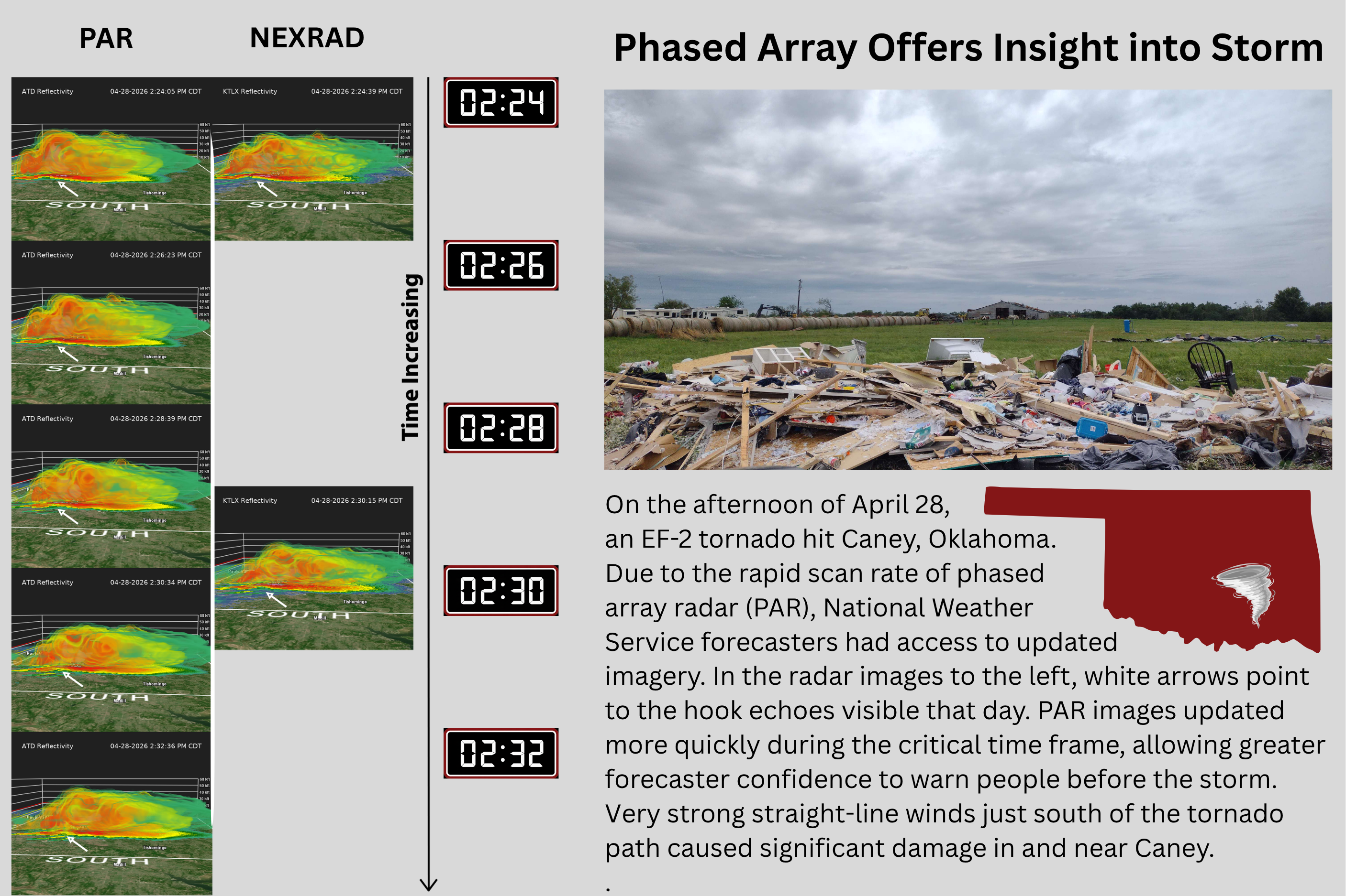
Meteorologists and engineers achieved a research milestone when phased array radar was used in operations for the first time ever to help National Weather Service forecasters warn of an EF-2 tornado.
The 3D Mesonet project aims to make advancements in gathering spatiotemporal atmospheric data in the United States, allowing scientists to better predict short-term, high-impact weather, like thunderstorms, severe winds and winter precipitation.
Greg McFarquhar, director of the Cooperative Institute for Severe and High-Impact Weather Research (CIWRO) and Operations and a researcher at the University of Oklahoma, has been awarded funding from the U.S. Department of Defense (DoD) to compile and analyze cloud property measurements from around the world.