By
Annette Price
Date
NORMAN, OKLA. –Broadcast meteorologists in the Baltimore, Washington, and Charlottesville, Va, television markets recently participated in a pilot program to demonstrate a new kind of training simulation on issuing severe weather warnings. National Weather Service (NWS) meteorologists Erik Taylor and Chris Strong from the Baltimore/Washington forecast office, visited the TV stations and guided the broadcasters through a simulation of an archived severe weather event using the so-called WES-in-the-Cloud system. WES-in-the-Cloud is a prototype version of a training tool -- a flight-simulator of sorts -- for NWS forecasters, that has been deployed into a cloud computing system rather than being only available at an NWS office.
The cloud simulation technology was jointly developed by the University of Oklahoma (OU) and the NWS Warning Decision Training Division. The broadcasters used the exact same tools that NWS forecasters use to diagnose the severe weather threat and to follow the actual process of issuing tornado and severe thunderstorm warnings.
Caitlin Roth, meteorologist for WTTG Fox 5 in Washington, said, “The project was invaluable for us on-air meteorologists to understand how and why different storms are warned for, and what that process looks like. Since we must clearly communicate what the threats are and where they are headed, it really helped to see what prompts NWS meteorologists to trigger a warning. We now have a deeper understanding on how these polygon shapes are decided and for how long they are issued. All this leads us to better communicating the severe weather threat quickly and accurately.”
“As a former broadcaster myself, the tendency on-air is to focus on the lowest [radar scan] while cycling through many different products and webcams when presenting a warned storm”, said Taylor. “This project gave the broadcasters a closer look into how warning decisions are made as well as basic radar interrogation focusing not only on the surface but aloft. They were in awe over the amount of training and quickness that goes into making warning decisions.”
Because Taylor and Strong conducted the simulations at each TV station, more broadcasters were able to participate. In total, 27 meteorologists in the Washington (4 stations), Baltimore (3 stations) and Charlottesville (1 station) markets participated in these exercises.
Ava Marie from WBAL in Baltimore said, “it was helpful to see what goes into the decision process.” Travis Koskho and AJ Willy from WCAV in Charlottesville were grateful for their partnership with the NWS and commented on how much they got out of it and were optimistic others felt the same.
Prior to the station visits, staff at the NWS Baltimore/Washington office created the two simulations used for this project and transferred the archived event data into the cloud system. Dale Morris and Ryan Pajela at the Cooperative Institute for Severe and High-Impact Weather Research and Operations (CIWRO) at OU configured the cloud system to use these events and ensured the system was available for the broadcasters when needed.
“I’m pleased that we could partner with the NWS Baltimore/Washington office in a pilot project to demonstrate some of the new capabilities that the WES-in-the-Cloud system will bring to the NWS”, said Dale Morris, senior research associate at CIWRO and project lead for the Weather Event Simulator.
“This new system will allow training simulations and demonstrations to be conducted almost anywhere and will enable lots of new types of exercises, like multiplayer simulations to focus on teamwork and communications as well as the science and technology of issuing weather warnings and forecasts,” said Morris.
“Our partners loved the interactivity and stressed this sort of project only enhances the aspect of trust along with building a more comprehensive relationship for the future,” said Taylor.
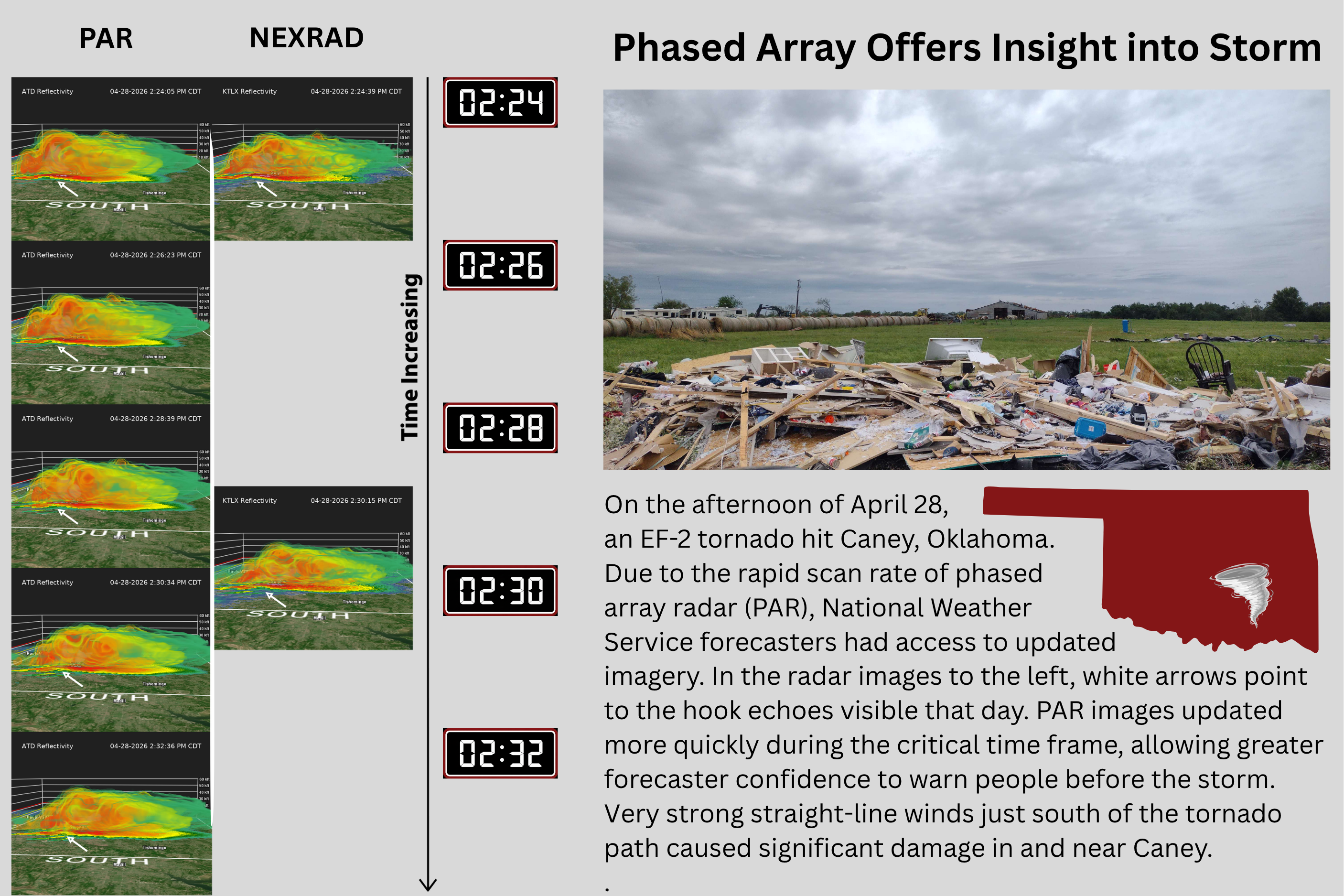
Meteorologists and engineers achieved a research milestone when phased array radar was used in operations for the first time ever to help National Weather Service forecasters warn of an EF-2 tornado.
The 3D Mesonet project aims to make advancements in gathering spatiotemporal atmospheric data in the United States, allowing scientists to better predict short-term, high-impact weather, like thunderstorms, severe winds and winter precipitation.
Greg McFarquhar, director of the Cooperative Institute for Severe and High-Impact Weather Research (CIWRO) and Operations and a researcher at the University of Oklahoma, has been awarded funding from the U.S. Department of Defense (DoD) to compile and analyze cloud property measurements from around the world.