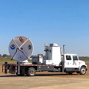
NORMAN—The University of Oklahoma’s Shared Mobile and Atmospheric Research and Teaching radar team, led by Michael Biggerstaff, departed for the East Coast Sunday afternoon to intercept Hurricane Florence with scientists from the National Oceanic and Atmospheric Administration’s National Severe Storms Laboratory. The team will encounter Hurricane Florence, a possible Category 3 or 4 hurricane, at landfall later this week. The two costliest hurricanes to hit the United States were Category 3 hurricanes, Katrina in 2005 and Harvey in 2017, whose Category 4 rating is under review because of wind analyses conducted by OU and NSSL.
“Florence will no doubt create significant storm surge and inland floods to go along with winds in excess of 110 miles per hour. We are interested in studying the inner core rain bands and eyewall convection,” said Biggerstaff, professor of meteorology, School of Meteorology, OU College of Atmospheric and Geographic Sciences. “As the hurricanes come ashore, the primary vortex circulation breaks down and creates deep waves in the atmosphere called Vortex Rossby Waves that generate rain bands that spin outward from the eyewall and contribute to inland flooding.”
“Isabel in 2003 and Harvey in 2017 both produced dozens of these rain bands at landfall,” said Biggerstaff. “Also, the VRWs can go inward toward the eye of the storm and generate mesocyclones along the inner eyewall that produce extreme wind gusts at the surface. Some of the most extensive wind damage associated with Harvey was along the path of its inner eyewall mesovortices.”
Team members Biggerstaff; Gordon Carrie, research scientists; Addison Alford and Noah Brauer, OU doctoral students; and Sean Waugh, NSSL scientists; deployed with a newly upgraded OU Cooperative Institute for Mesoscale Meteorological Studies’ C-band dual-polarimetric SR3 radar, four OU and Purdue University Portable Integrated Precipitation Sensors that carry a disdrometer to study the size distribution of raindrops in addition to standard weather station instruments, an experimental wind sensor and an NSSL mobile mesonet that serves as a weather balloon launch vehicle.
Waugh and Alford launched balloons into the eye of Harvey and Irma and discovered some of the highest values of precipitable water ever observed over the mainland. High precipitable water (a measure of total humidity in a column of air) is associated with potential flooding. Both Harvey and Irma produced extensive flooding over land. It remains to be determined if such high values of precipitable water are common in all hurricanes. Waugh and the OU students will penetrate the eyewall and launch a weather balloon instrument into the eye of Florence. Additional weather balloons will be conducted to aid the radar-derived wind analyses and determine the wind and temperature perturbations within the vortex Rossby wave bands.
OU is part of multi-agency, multi-university Digital Hurricane Consortium that fields research instruments in advance of landfalling hurricanes. The team coordinates with scientists from the NOAA Hurricane Research Division who fly in the NOAA P3 aircraft and measure the storm’s circulation prior to landfall. OU’s collaboration with AT&T and the Weather Channel allows the team to provide live updates of the SR3 observations made daily to the public and interested parties.
Using software developed by Alford and Carrie, the team plans to combine the SMART radar data with nearby National Weather Service radar data to produce the first ever near-real-time wind analyses during the landfall of a major hurricane. If successful, maps of maximum wind speed and its time of occurrence will be generated. Once the radar is deployed and operating, likely Wednesday afternoon, a link to the website containing radar observations will be available.
For more information about the OU SMART radar team, contact Biggerstaff at drdoppler@ou.edu or 405-623-1769. The camera links are: Side View: https://video.nest.com/live/6J5c8PIWhN and Cab: https://video.nest.com/live/g0FgtWh9RJ.


