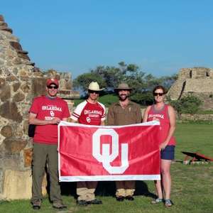
In Mesoamerica, where geophysical survey is still fairly new, researchers from the University of Oklahoma are working on one of the largest and most comprehensive projects to date. Using ground-penetrating radar and other techniques, they’re gaining new archeological insights without disturbing the main plaza at Monte Albán. We spoke to Scott Hammerstedt, an OU Archeologist who was on site at the geophysical survey in Oaxaca, Mexico to learn more about this compelling new research project.
Q: Can you tell us about the project you are working on in Oaxaca and who you’re working with?
A: The Principle Investigator for the project is Marc Levine, Assistant Curator of Archaeology at the Sam Noble Museum and Assistant Professor in the Anthropology Department here at OU. Other involved researchers are myself, Amanda Regnier; Director, Oklahoma Archeological Survey, and Marcus Winter from the Oaxaca center of the Instituto Nacional de Antropología e Historia. The project utilizes several geophysical prospection techniques to see below the ground surface of Monte Albán’s main plaza—the urban core of a city founded around 500 BCE. We also used a drone to take tens of thousands of photos, which will allow us to create a topographic map and 3-D renderings of the main plaza and associated buildings.
Q:How did the team at OU get involved in this project?
Marc Levine has been working in Oaxaca for many years. He invited us to work with him at Monte Albán because of our expertise in geophysical prospection and then he obtained funding from the National Geographic Society and the University of Oklahoma.
Q: What are some of the goals of the project?
A: The main goal of the project is to investigate what Monte Albán looked like during its early history and better appreciate the amount of work that went into its construction. Monte Albán is often cited as one of Mesoamerica’s earliest state-level societies, but we’d like to know more about its founding and early development. We used three geophysical techniques to scan below the surface of the site’s main plaza: magnetometry, electrical resistance, and ground-penetrating radar. These instruments allow us to detect archaeological features beneath the soil without excavation. We hope to discover buried structures or other features, such as tombs, tunnels, or offerings. We also hope to gather data to estimate the amount of dirt used to level the plaza surface, which was built on an uneven hilltop. This will tell us more about social and political organization at the center.
Q: When did the project start and how long will it last?
A: We started on June 15 and finished July 14.
Q: Have there been any discoveries so far you can share with us?
A: We have lots of promising data, but nothing we can officially share without first notifying the National Geographic Society. But stay tuned.
Q: What has been your favorite part about the project?
A: Working at such an important site has been a lot of fun. I think all of us have enjoyed going to work there every day. We use similar geophysical techniques at sites in Oklahoma, notably at Spiro Mounds, so applying them to a different area was a great experience.
Q: What challenges have you faced doing this work?
A: Surprisingly few, at least in terms of the archaeology. Dealing with thousands of tourists while trying to work was somewhat challenging.
Q: How have you overcome those challenges?
A: Orange cones, an interpretive sign, and lots of patience for questions in many languages.
Q: Finally, why is this work important?
A: First, geophysical survey is still new in Mesoamerica. Our work is one of the most comprehensive and largest projects to date. Second, it provides new archaeological information in a non-destructive manner. Third, by exposing our work to the general public, it shows them that there are still important things to be learned about Monte Albán. It’s important to show that we don't already know it all. This point also applies to sites such as Spiro back in Oklahoma. Finally, geophysical techniques can help conservation efforts by indicating where archaeological features lie underfoot so that they can be protected in the future.


